Passage — Defence

Better situational pictures. Faster orientation. Sovereign 3D data spaces.

Defence · public safety (BOS) · security agencies · planning

aratall GmbH

As of 2026-06

The missing 3D layer for the operating picture

Defence primes and systems integrators are working on D-LBO, situational awareness, counter-UAS and digital mission support. What is often missing: A sovereign, vendor-neutral 3D layer for geodata, structures, drone feeds and live sensors. Passage delivers this component as a bring-along — interoperable with existing C2 and situational-awareness systems.

Platform highlights

Passage — at a glance

What the platform delivers — in 15 seconds.
  • Available
  • In preparation
  • Roadmap
  • One data foundation, five views

    (Available)
    Map, 3D on screen, AR tabletop, VR headset and on-site AR — no break between command post, training and the field.
  • Live & shared

    (Available)
    Every view is multi-user and synchronised in real time, with video call and chat built in.
  • Your data, your sovereignty

    (Available)
    Cloud, on-premises or air-gapped — your choice. Your data stays with you.
  • Open & sovereign

    (In preparation)
    Open-source stack, no vendor lock-in. Open interfaces to your systems and sensors.
  • Alliance-ready

    (In preparation)
    Built for NATO-standard interoperability (Cursor-on-Target in preparation, STANAG roadmap).
  • Secure & compliant

    (In preparation)
    VS-NfD readiness in preparation · NIS-2 in preparation · Quality management to ISO 9001 roadmap · AQAP roadmap.

Full technical brief on request.

Operating picture

Dynamic Digital Twin

From existing data: Terrain models, plans, point clouds and geodata — assembled into one consistent twin.

Current through new data: Sensors, drones and live imagery — each source a layer, instantly in the operating picture.

Sovereign: On-premises, air-gap capable.

Dynamic Digital Twin

In action

Drones & sensors in the operating picture

Live operating picture: drone feed, multi-sensor fusion, dynamic digital twin and AI-assisted decision support fused into one shared 3D picture.

Three layers, one platform

Information superiority in the field

The same capabilities — in multi-use also for public safety (BOS), security agencies and planning.

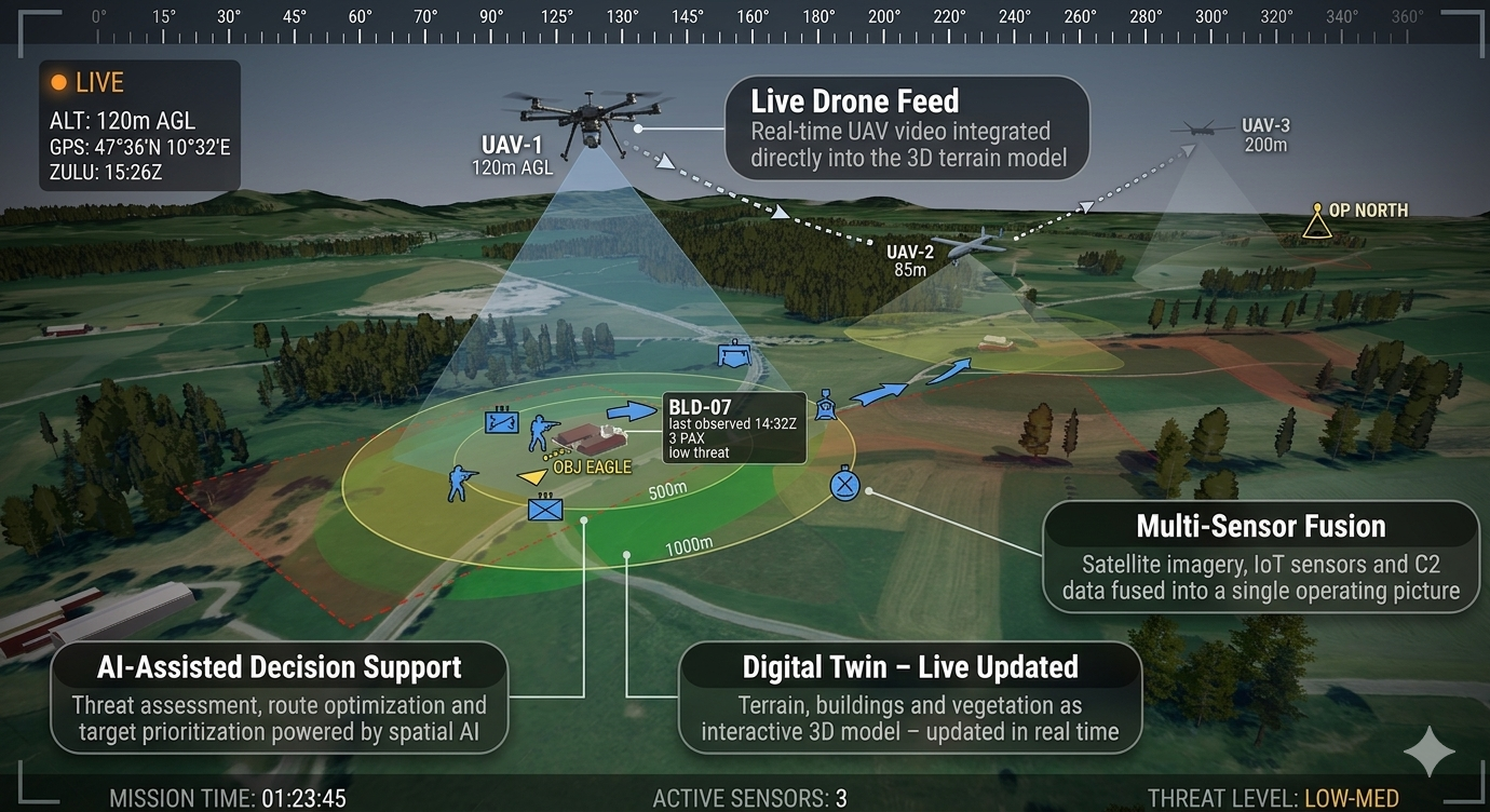
The missing layer: overlaying space and imagery onto the C2 situational picture

Situation
A command post already runs its picture in a C2 / command-and-control information system. Positions, reports and tracks converge there.
The problem today
C2 systems consolidate structured data well — but they show the situation flat. At least one information layer is missing: the imagery, the spatial orientation, the real 3D dimension in the terrain. Elevations, lines of sight, structures, interiors — not tangible in a 2D symbol view.
With Passage
Passage builds on the existing operating picture instead of replacing it. It takes the same data and adds the missing layer: terrain and structures in true 3D, imagery sources located in space, elevations and lines of sight made tangible. The symbol on the map becomes the place in the terrain.
Result
The picture gains the spatial dimension the C2 system lacks — without a change of system, as an addition.

Drone and counter-UAS: click the target, hand it to the allied stack

Situation
Several drones reconnoitre an urban area of operations; at the same time a hostile drone must be detected and reported.
The problem today
Each drone feed runs in its own window, with no relation to the terrain and no clean connection to NATO / allied systems. To hand over a target means: retype, translate, hope.
With Passage
The feeds of several drones are fused into one picture and located in the 3D operating picture. Click-on-Target sets a coordinate on a specific building — down to the floor — and passes it on as a Cursor-on-Target (CoT) message into the allied stack.
Result
From detected target to handed-over coordinate in seconds — interoperable instead of an isolated solution.

Property / operations room: set up once, always up to date

Situation
A property or an operations room is used jointly by command, reconnaissance and training.
The problem today
The existing data is 2D, scattered and outdated. Everyone works from their own version — command differently from the troops on the ground, training differently again.
With Passage
The space is set up once from existing data (3D Tiles, point clouds, terrain models, plans) as a twin and updated daily through overflights and walkthroughs. The same truth at every station: command on screen, the team on-site in AR, training in VR.
Result
One truth, many stations — no “my picture versus your picture”.

Contact

What we’re looking for

A conversation about partnerships and consortia for research and product development — at national and European level (EDF · EUDIS).

Direct contact

Stefan Werner Kauling

CEO · aratall GmbH

Albert-Einstein-Straße 1, 49076 Osnabrück

+49 541 931 339 10

s.kauling@aratall.com

linkedin.com/in/swkatparis

Registered office: Albert-Einstein-Straße 1, 49076 Osnabrück · Managing Director: Stefan Werner Kauling · Osnabrück Local Court HRB 216523 · NCAGE applied for · BDSV membership — application in preparation.